Geolocation is the locating of something using digital technology, usually on a map-like interface. Over the last decade, we have seen some great advances in geolocation and digital mapping with the rise of Google Maps, Google Earth, Bing Maps and many other services.
Google first purchased its map service in 2004 from a small Australian company and it has grown exponentially. At the Salford Business School’s Centre for Digital Business we have experimented with the latest geolocation tools with some exciting results. These projects visualise our world even further, combining location information with valuable social and business intelligence.
Geolocation API
Our world is now mapped out and overlaid in many cases to individual house level. Tools like Google Street View allow you to explore the world from the comfort of your home as never before. Many of these services have free to use APIs (application programming interfaces). APIs are making the map information available to be used in many different ways by people and businesses around the world.

Adding local voices to local stories
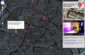
One example of geolocation in action is our Onlocation.org uk project. This features a website and an app, helping anyone to share local news and stories. The project empowers people to very quickly and conveniently capture and combine video, audio, image and text to tell a story and report things around the local community map. This project was a partnership between the University of Salford, MediaCityUK and the University of Bolton. Onlocation was used to a great effect recently for combining multimedia to map out the story of the Digital Economy Conference at MediaCityUK.
Geolocation API for business users
There is also vast potential for these technologies and business (click here for some geolocation business examples). Google’s new ‘Maps for Business’ service was launched in 2013:
“Google wants to turn business owners into cartographers with a new mapping tool designed to visualize their companies’ data.” (PCWorld magazine, 21 October 2013)
Geolocation API as a business advantage
The potential to improve supply chain, communications and customer communications for map geolocation APIs is vast. There will be many ways in which business people could map out their business world and logistics. B2C (business-to-consumer) companies could be reaching out to their target audience in many ways using maps, for example adding location-based offers, products and services. Click here for a Google Maps API business example from Pure Fix Cycles.
Over half of US-based companies are using digital maps in some element of their business and geolocation applications are rising globally. All businesses have various data sets and most have location based information. So, with the geolocation API tools we have available to us, the next step for businesses is to decide how they could best make this work for their business or project.
Smartphone and geolocation
The rise of smartphones and social media tools also means that geolocation has never been more popular. We now have a fully fledged computer in our pocket, capable of displaying complex map information. Your smartphone knows exactly where it is in the world and is capable of recording location, video and sound. Providing real time location information also has powerful potential for business engagement.
How have you used geolocation?
Do you have any brilliant geolocation ideas? If you would like to discuss how Salford Business School could assist with you with your idea, do not hesitate to get in touch with our Centre for Digital Business.